An attack on a buried network by a construction machine is a scenario that infrastructure operators treat as a priority. They therefore need to constantly pinpoint the precise location of their works and guide contractors to limit this risk.
New technologies offer a real opportunity to prevent these network attacks. One of the challenges is therefore to identify the most innovative technologies and mobilize all available resources to lead our teams towards this goal.
As part of the research program dedicated to designing tomorrow's operational equipment, RICE teams and various gas infrastructure operators are exploring tools for detecting and visualizing buried networks. New technologies in the fields of detection, geomatics and augmented reality are key activities, facilitating the collection and interpretation of information, and making it available in the field.
A reliable, high-performance geographic information system (GIS), available everywhere in real time and delivering quality data.
Network geolocation data can be judiciously supplemented by adding depth, flow rate, pressure or time data. This information will bring value to the teams, such as tackling uncertainties and removing doubts about a section, enabling GRTgaz to improve its operational performance.
Reliable and precise detection of a network's position enables us to significantly reduce damage to buried pipes. With this in mind, RICE and its teams continue to monitor technology and test pipe detectors at its dedicated test areas in Villeneuve La Garenne and Alfortville. Recently, the question of how to capitalize on detection data collected in the field has given us food for thought when it comes to developing innovative solutions for field operators. Thanks to new telecommunications resources and the increasing power of mobile terminals, it is now possible to store all this field detection data and make it instantly accessible to the greatest possible number of people. This not only improves the performance of our field teams in their marking operations, but also contributes to the enrichment of our GIS data.
For example, manufacturers of GPR (Ground Penetrating Radar) or electromagnetic detectors now offer integrated couplings with IOT (*) and/or GNSS rtk (*). These developments encourage and facilitate the emergence of solutions such as those described above.
From an ergonomic point of view, augmented reality also appears to be a tool that operators will be able to use in the field in the near future.
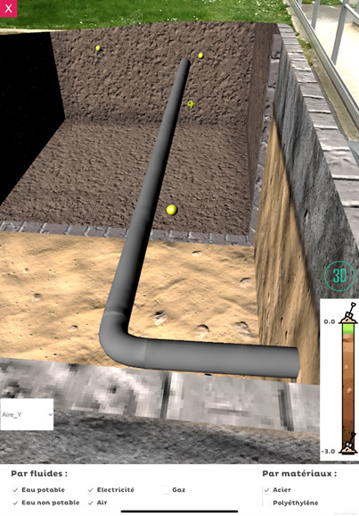
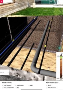
Transparensee is the application developed by RICE to display underground networks in augmented reality. This application, which can now be used in the laboratory, enables our GRTgaz teams and our customers to project themselves towards the use of new technologies with complete peace of mind. By using GIS data through these augmented reality tools, operators can reduce the risk of network damage.
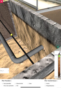

Augmented reality is now joined by connections to sub-centimeter geolocation systems. With precise geo-referencing information at your fingertips, a number of uses can be realized:
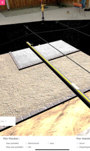
Augmented reality is also about hardware. RICE is experimenting with mixed reality headsets, as well as LiDAR and related applications.
All these uses and all these service configurations will enable us to improve gas accident prevention, but also to offer our customers the best technologies and proven technical devices.
(*) IOT: Internet of Things
(*) GNSS: Global Navigation Satellite Systems
(*) rtk: Real Time Kinematic


